Quaternary Deposits as the Hydrogeological System of Eastern Slavonia
Article Sidebar
Published:
Nov 9, 2010
Keywords:
Hydrogeological system, Watershed, Lithological continuity, Fault zones, Transmissivity, Plateau, Eastern Slavonia, Croatia
Main Article Content
Abstract
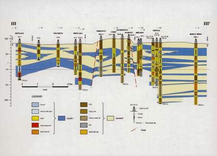
The area of eastern Slavonia, situated between the Drava andSava rivers, comprises three geotectonic units: the eastern part of theDrava depression in the north, part of the Slavonia-Srijem depressionin the south and the central Ðakovo-Vinkovci plateau together withthe Vukovar plateau. These units are separated by deep faults thatreach the base of the Tertiary sediments. The first 200 m of Quaternarydeposits are saturated with fresh water. The aim of this studywas to find out whether the faults form impermeable boundaries separatingthe waterbearing deposits into independent hydraulic systems,or if a singular hydraulic entity exists. Results of the analysis indicatethat lithological continuity of the aquifers exists along the fault zoneson the margins of the Ðakovo-Vinkovci and the Vukovar plateaux,which means that there is no impermeable hydraulic boundary on thewatershed between the Sava and Drava river valley. The part of easternSlavonia between the Sava and Drava rivers is one hydraulic systemconsisting of zones with different transmissivity values. In thezones of reduced transmissivity, the hydraulic connections are weakened,but not broken. Such zones exist not only along the fault zonesof the Ðakovo-Vinkovci plateau and the Vukovar plateau, but alsowithin the Sava and Drava depressions. The terrain morphology influenced formation of both the surface and the underground watershed, parallel to the extension of the Ðakovo-Vinkovci and Vukovarplateau. Therefore, within this single hydraulic entity, when the drawdownreaches the watershed due to excessive pumping, the watershedwill be displaced from its natural position.
Downloads
Download data is not yet available.
Article Details
Issue
Section
Original Scientific Papers
Authors have copyright and publishing rights on all published manuscripts.