
On the origin of both a recent and submerged tombolo on Prvić Island in the Kvarner area (Adriatic Sea, Croatia)
Article Sidebar
Main Article Content
Abstract
This paper analyzes the origins of two tombolos (one recent and another fossil/submerged) on the southwestern coast of Prvić Island, which is located in the Kvarner area in the northeastern part of the Adriatic Sea.
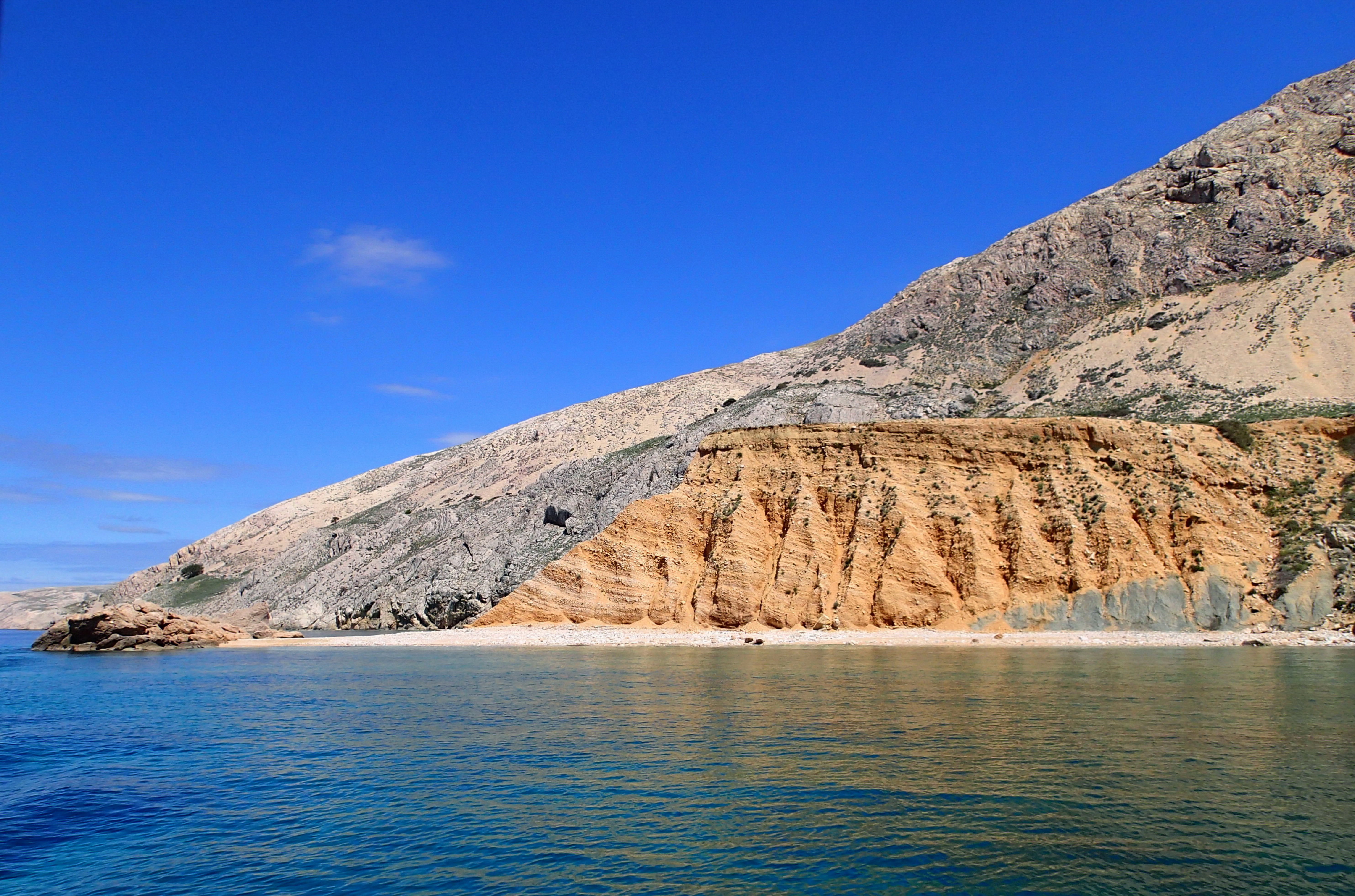
A recent tombolo on Cape Pipa was formed by the erosion of Quaternary deposits and Palaeogene siliciclastic rocks. The submerged tombolo is much bigger, clearly visible on the sea bed toward the southwest. The conditions for forming a submerged and recent tombolo have occurred during a slow rise and then stagnation of sea level of the Adriatic Sea in the Holocene. The sea flooded the fossil tombolo probably in the final part of a period of rapid sea-level rise at the beginning of the Holocene when a large proportion of the Quaternary sediments were eroded. Waves from the northwest (tramuntana) and southeast (jugo) refract and diffract around the tombolo. The nourishment of the beach body happens permanently on both sides of the cape. Accumulated sediments are protected by resistant rocky blocks of breccia on the peak of Cape Pipa, acting as a natural tombolo. Due to the fact that wave directions are perpendicular to the beach coastline, they do not generate longshore currents that would erode sediment in beach bodies around Cape Pipa. Therefore, the recent tombolo is probably stable in the present climatic and oceanographic conditions in the Kvarner area.
Downloads
Article Details

This work is licensed under a Creative Commons Attribution 4.0 International License.
Authors have copyright and publishing rights on all published manuscripts.
References
BENAC, Č. & JURAČIĆ, M. (1998): Geomorphological indicators of the sea level changes during Upper Pleistocene (Wuerm) and Holocene in the Kvarner region. Acta Geographica Croatica 33, 27-45.
BOOIJ, N., RIS, R.C. & HOLTHUIJSEN, L.H. (1999): A third-generation wave model for coastal regions, Part I: Model description and validation. Journal of Geophysical Research 104 (C4), 7649-7666.
CEYLAN, M. A. (2012): General Overview of the Tombolos on Turkey’s Coastlines. World Applied Sciences Journal, 16 (7). 907-914.
COWELL, P.J. & THOM, B.G. (1997): Morphodynamics of coastal evolution. -In: CARTER, R.W.G. & WOODROOFE, C.D. (eds.): Coastal evolution. Cambridge Univ. Press, Cambridge, 33-86.
DUPLANČIĆ LEDER, T., UJEVIĆ, T. & ČALA, M. (2004): Coastline lengths and areas of islands in the Croatian part of the Adriatic Sea determined from the topographic maps at the scale of 1:25 000. Geoadria 9/1, 4-32. doi: 10.15291/geoadria.127
FLINN, D. (1997): The role of wave diffraction in the formation of St. Ninian's Ayre (Tombolo) in Shetland, Scotland. Journal of Coastal Research 13, 202–208. doi: 10.2112/JCOASTRES-D-12-00
GAMS, I., ZEREMSKI, M., MARKOVIĆ, M., LISENKO, S. & BOGNAR, A. (1985): Uputstvo za izradu detaljne geomorfološke karte 1: 100 000 (A guide to making a detailed geomorphological map 1: 100 000- in Croatian). Komisija za geomorfološko kartiranje SFRJ, Beograd, 80 p.
GOSSEAUME, E. (1973): Le tombolo triple d'Orbetello (Toscane). Bulletin de la Société Languedocienne de Géographie 7, 3–11.
HANSOM, J.D. (2003): St Ninian's tombolo. In: MAY, V.J. AND HANSOM, J.D. (eds.): Coastal Geomorphology of Great Britain. Geological Conservation Review, 28, 1-5.
JURAČIĆ, M., BENAC, Č., PIKELJ, K. & ILIĆ, S. (2009): Comparison of the vulnerability of limestone (karst) and siliciclastic coasts (example from the Kvarner area, NE Adriatic, Croatia). Geomorphology, 107 (1-2), 90-99.
doi: 10.1016/j.geomorph.2007.05.020
KAN, H., HORI, N., KAWANA, T., KAIGARA, T. & ICHIKAWA, K. (1997): The evolution of a Holocene fringing reef and island: reefal environmental sequence and sea level change in Tonaki Island, the central Ryukyus. Atoll Research Bulletin, 443, 1-20.
LAMBECK, K., ANTONIOLI, F., PURCELL, A. & SILENZI, I.S. (2004): Sea-level change along the Italian coast for the past 10,000 yr. Quaternary Science Reviews, 24, 1567-1598. doi: 10.1016/j.quascirev.2004.02.009
LEDER, N., SMIRČIĆ, A. & VILIBIĆ, I. (1998): Extreme values of surface wave heights in the Northern Adriatic. Geofizika, 15, 1–13.
MAMUŽIĆ, P., MILAN, A., KOROLIJA, B., BOROVIĆ, I. & MAJCEN, Ž. (1969): Osnovna geološka karta SFRJ 1:100.000, list Rab L 33-114. (Basic Geological Map of SFRY 1:100.00, Rab sheet – in Croatian). Institut za geološka istraživanja, Zagreb. Savezni geološki zavod, Beograd.
MARRINER, N., MORHANGE, C. & MEULÉ, S. (2007): Holocene morphogenesis of Alexander the Great’s isthmus at Tyre in Lebanon. PNAS, 104(22), 9218–9223. doi.org/10.1073/pnas.0611325104
MARRINER, N., GOIRAN, J.P. & MORHANGE, C. (2008): Alexander the Great's tombolos at Tyre and Alexandria, eastern Mediterranean. Geomorphology, 100 (3-4), 377–400. doi: 10.1016/j.geomorph.2008.01.013
MARJANAC, LJ. (2012): Pleistocene glacial and periglacial sediments of Kvarner, northern Dalmatia and southern Velebit Mts. - evidence of Dinaric glaciation. PhD thesys. Prirodoslovno-matematički fakultet, Zagreb, 278 p.
ORLIĆ, M. & PASARIĆ, Z. (2013): Semi-empirical versus process-based sea-level projections for the twenty-first century. Nature Climate Change, 3, 735-738. doi: 10.1038/nclimate1877
PAVLOPOULOS, K., EVELPIDOU, N. & VASSILOPOULOS, A. (2009): Mapping Geomorphological Environments. Springer, Dordrecht-Heidelberg-London-New York, 236 p. doi: 10.1007/978-3-642-01950-0
PENZAR, B., PENZAR, I. & ORLIĆ, M. (2001): Vrijeme i klima hrvatskog Jadrana, Biblioteka Geographia Croatica, 16, Hrvatski hidrografski institut, Split, 258 p.
PIKELJ, K. & JURAČIĆ, M. (2013): Eastern Adriatic Coast (EAC): Geomorphology and Coastal Vulnerability of a Karstic Coast. Journal of Coastal Research, 29 (4), 944-957.
doi: 10.2112/JCOASTRES-D-12-00136.1
PIKELJ, K. & JURAČIĆ, M. (2009): Origin and distribution of surface sediments in the Grgur Channel, Adriatic Sea, Croatia. Geologia Croatica, 62 (2), 95-105. doi: 10.4154/GC.2009.08
RUŽIĆ, I., BENAC, Č., MAROVIĆ, I. & ILIĆ, S. (2015): Stability assessment of coastal cliffs using digital imagery. Acta Geotechnica Slovenica, 2015 (2), 25-35.
SANDERSON, P. G. & ELIOT, I. (1996): Shoreline Salients, Cuspate Forelands and Tombolos on the Coast of Western Australia. Journal of Coastal Research, 12(3), 761-773.
SCHWARTZ, M.L., GRANO, O. & PYOKARI, M. (1989): Spits and tombolos in the southwest archipelago of Finland. Journal of Coastal Research, 5, 443-451.
SURIĆ, M. (2009): Reconstructing sea-level changes on the Eastern Adriatic Sea (Croatia) – an overview. Geoadria, 14 (2), 181-199. doi: 10.15291/geoadria.550
TSIMPLIS, M.N., RAICICH, F., FENOGLIO-MARC, L., SHAW, A.G.P., MARCOS, M., SOMOT, S. & BERGAMASCO, A. (2009): Recent developments in understanding sea level rise at the Adriatic coasts. Physics and Chemistry of the Earth. Parts A/B/C, 59-71. doi: 10.1016/j.pce.2009.11.007
TORAB, M. (2016): Geomophological & Geoarchaeological Indicators of the Holocene Sea-Level Changes on Ras El Hekma Area, NW Coast of Egypt, Journal of African Earth Sciences, 114, 85-95. doi: 10.1016/j.jafrearsci.2015.11.001
URL 1: https://geoportal.dgu.hr/Geoportal, Državna geodetska uprava, Zagreb.
VU, M. T., LACROIX, Y. & NGUYEN, V. T. (2018a): Investigating the effects of sea-level rise on morphodynamics in the western Giens tombolo, France. IOP Conference Series: Earth and Environmental Science (EES) 167, 1-8. doi: 10.1088/1755-1315/167/1/012027
VU, M. T., LACROIX, Y. & NGUYEN, V. T. (2018b): Empirical Equilibrium Beach Profiles Along the Eastern Tombolo of Giens. Journal of Marine Science and Application, 17(2), 241–253. doi: 10.1007/s11804-018-0027-3
WARD, S. (2004): Tombolo. In: GOUDIE, A.S. (ed.): Encyclopedia of geomorphology. Rutledge, IAG, London–New York, 1054 p.